Trail Mountain bike La Faurie - pusteaux - agnielles - col longeoire -  - Photo

pusteaux - agnielles - col longeoire -

© OpenStreetMap contributors
Length
Length
43 km
Max alt
Max alt
1621 m
Uphill gradient
Uphill gradient
1278 m
Km-Effort
Km-Effort  
60 km
Min alt
Min alt
799 m
Downhill gradient
Downhill gradient
1275 m
Boucle
Boucle
Yes
Creation date :
2021-08-17 11:46:52.911
Updated on :
2021-08-17 16:18:58.981

(0 Reviews)

Mountain bike
Mountain bike
3h42
Difficulty : Easy

Scan this QR Code to open this trail in the SityTrail application

FREE GPS app for hiking

Logo SityTrail SityTrail

IGN / Geographical institutes

Download SityTrail from the App Store Download SityTrail from Google Play

Logo SityTrail SityTrail World

The world is yours!

Download SityTrail from the App Store Download SityTrail from Google Play Download SityTrail on Huawei AppGallery

About

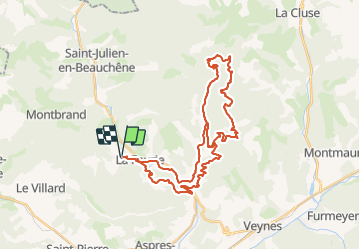
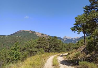
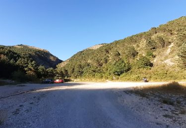
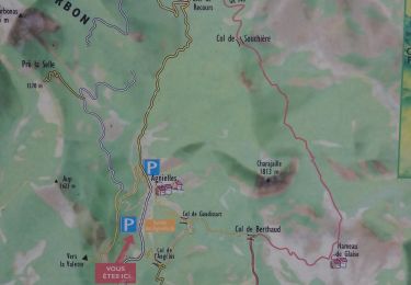
Trail Mountain bike of 43 km to be discovered at Provence-Alpes-Côte d'Azur, Hautes-Alpes, La Faurie. This trail is proposed by jcpistono.

Description

pusteaux - seilles - pont la dame - cil angelus - agnielles - recours - la lauze  - col angelus - agnielles - pusteaux
43km 1275mdev - quasiment en totalité  sur pistes forestieres - tres agreable et facile en vttae

Elevation profile

Positioning

Country:
France
Region :
Provence-Alpes-Côte d'Azur
Department/Province :
Hautes-Alpes
Municipality :
La Faurie
Location:
Unknown
Start:(UTM)
716585 ; 4938630 (31T) N.

Trails nearby

Trail Walking La Faurie - R40   Les Marmites du Diable - Photo
Walking
GUIDE+

Walking

Medium
(6)
La Faurie, Provence-Alpes-Côte d'Azur, Hautes-Alpes, France
5.9 km | 10.4 km-effort
2h 7min
Yes
Trail Walking Aspres-sur-Buëch - R42   La Longeagne - Photo
Walking
GUIDE+

Walking

Very easy
(1)
Aspres-sur-Buëch, Provence-Alpes-Côte d'Azur, Hautes-Alpes, France
7.1 km | 11.2 km-effort
2h 23min
Yes
Trail On foot Montbrand - 9587037(1) - Photo
On foot
GUIDE+

On foot

Easy
Montbrand, Provence-Alpes-Côte d'Azur, Hautes-Alpes, France
3.5 km | 4.6 km-effort
1h 2min
Yes
Trail On foot Aspres-sur-Buëch - 9587028 - Photo
On foot
GUIDE+

On foot

Easy
Aspres-sur-Buëch, Provence-Alpes-Côte d'Azur, Hautes-Alpes, France
3.4 km | 5.3 km-effort
1h 12min
Yes
Trail Mountain bike Aspres-sur-Buëch - Gorges de l'Agnielle - Photo
Mountain bike
jeanboulay

Mountain bike

Medium
Aspres-sur-Buëch, Provence-Alpes-Côte d'Azur, Hautes-Alpes, France
12 km | 16.7 km-effort
2h 25min
Yes
Trail Mountain bike Saint-Pierre-d'Argençon - HA J3 long - Photo
Mountain bike
thierryd

Mountain bike

Very easy
(4)
Saint-Pierre-d'Argençon, Provence-Alpes-Côte d'Azur, Hautes-Alpes, France
34 km | 42 km-effort
2h 45min
No
Trail Walking La Faurie - les marmites du Diable - Photo
Walking
Thierry.T

Walking

Difficult
La Faurie, Provence-Alpes-Côte d'Azur, Hautes-Alpes, France
6.1 km | 10.4 km-effort
2h 59min
Yes
Trail Walking Montbrand - montbrand - Photo
Walking
xcreator

Walking

Easy
Montbrand, Provence-Alpes-Côte d'Azur, Hautes-Alpes, France
3.8 km | 5.1 km-effort
1h 3min
Yes
Trail Walking La Faurie - SityTrail - SityTrail - La Vallette - Agnielles - Marmites du Diable - Photo
Walking
kurt-vh

Walking

Very difficult
La Faurie, Provence-Alpes-Côte d'Azur, Hautes-Alpes, France
15.6 km | 28 km-effort
6h 15min
Yes


Close
My subscriptions